
Mt. Arafune
2.5-Hour Hike to the Summit
Mt. Arafune – Uchiyama Pass Trail Highlights
Enjoy a Geo-Hike While Discovering the Wonders of a Geosite!
Mt. Arafune stands out among the surrounding rugged peaks with its flat summit, which resembles a battleship floating on stormy seas—hence the name “Arafune” (meaning “rough boat”).
Why is the top of this mountain so flat? As you hike, try to imagine how this unique landscape came to be!
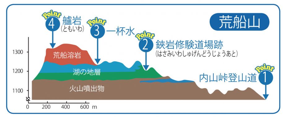
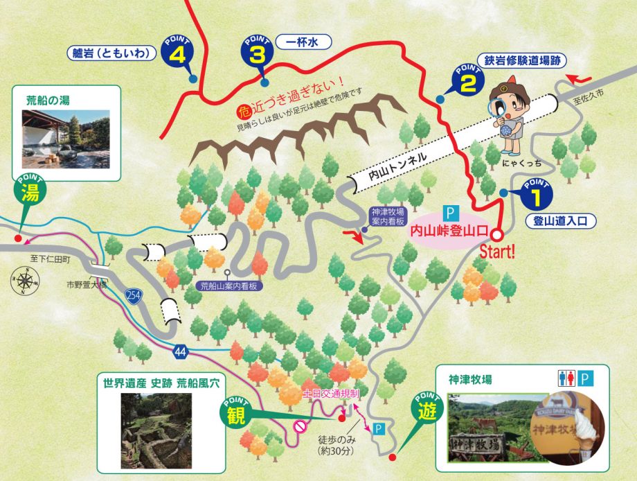
Point 1: Trailhead Entrance
Take a close look at the surrounding rocks. You’ll see stones embedded within them—these are volcanic materials. During past eruptions, volcanic ash covered the area, trapping pieces of lava and stone within the rock layers.
Point 2: Former Shugendo Training Grounds at Hasami Rock
This area was once home to a training hall for ascetic monks who practiced on Mt. Arafune. The stone foundations still remain today. Behind it, the cliff face reveals layers of lakebed sediments from before the Arafune lava flows. You can still see beautiful striped patterns created by the accumulated layers.
Point 3: Ippai-mizu (Natural Spring)
Here, the cliff changes character. Unlike earlier layered rock, it becomes a smooth, jet-black layer—this is lava that flowed around 8 to 7 million years ago. From this point onward, you’ll climb along this ancient lava plateau. Take a break and enjoy a sip of fresh spring water flowing from the volcanic rock.
Point 4: Tomoiwa Cliff
You can stand right on the edge of the towering Tomoiwa Cliff. On clear days, the majestic Mt. Asama is visible in the distance.
World Heritage Site – Arafune Wind Cave
This natural refrigeration facility was used to store silkworm eggs by harnessing cold air from a landform known as an “ice-sui.” It played a vital role in Japan’s silk industry during the Meiji and Taisho periods by allowing farmers to control when eggs hatched. The cool air still blows today.
Best time to experience the wind: June to September
Closed in winter: December 1 – March 31
Kozu Ranch – Jersey Cows and Green Meadows
Japan’s oldest Western-style highland ranch
Set amidst rolling green pastures, the pointed-roof barns feel like something out of the Alps. Jersey cows with soft brown coats, goats, and ponies freely roam the land. Don’t miss the delicious soft-serve ice cream and dairy products made from fresh Jersey milk! Meals are also available—how about lunch while soaking in the refreshing mountain breeze?
Hiking Safely
- Some parts of the trail include chain-assisted sections. Wear sturdy hiking shoes, bring rain gear, enough food and water, and be sure to follow trail etiquette for a safe and enjoyable experience.
- Beware of bears! Carry a bell or hike in a group for safety.