3 Geo Highlights of Shimonita
Uncover the Story of Rootless Mountain
1. From Ocean to Land: The Great Geological Shift that Created the Rootless Mountain
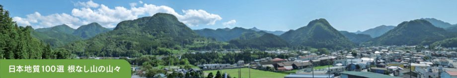
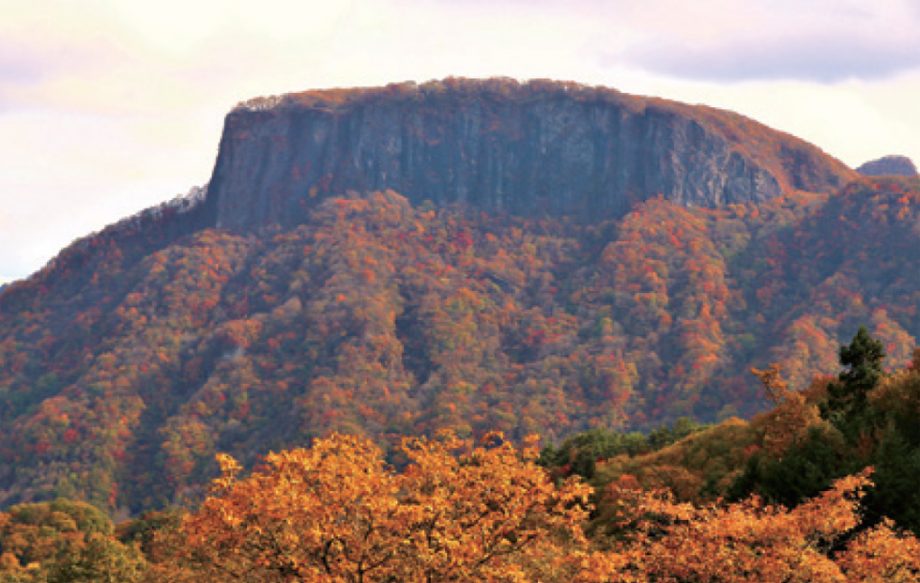
The mountain ridges visible from the town resemble the softly rounded peaks seen in old folktales.
The Rootless Mountain (Klippe), selected as one of Japan’s Top 100 Geological Sites, is made of ancient rocks that once formed part of the eastern edge of the Asian continent and were thrust up and over to their current position on the Pacific side.
This region also contains high-quality limestone formed under the sea, which has been extensively used. Additionally, the stony slopes along the mountains have been well-suited to konjac cultivation.
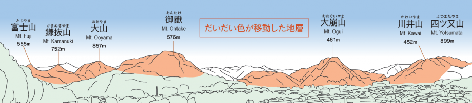
The orange area is the strata that have been moved.
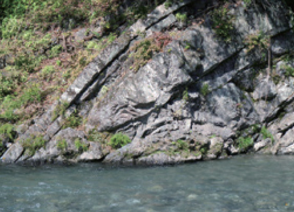
Traces of the Great Movement of the Earth
Slip Surface of the Atogura Klippe
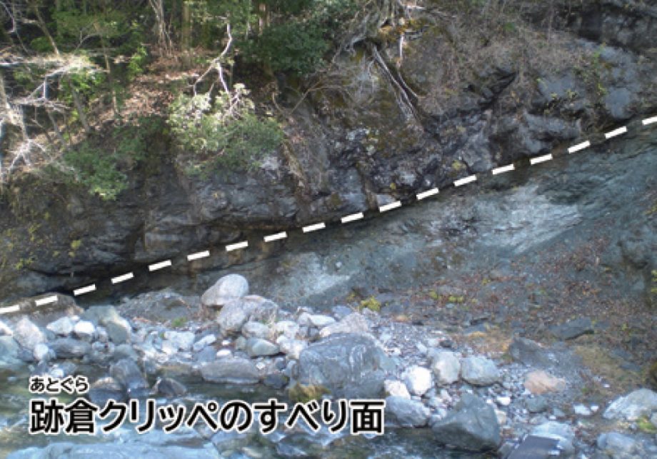
This marks the boundary where the overlying strata moved in. You can observe the frictional textures created as the rock mass slid over.
Folding in Okuwabara
Here you can see layers of rock that were bent and folded under immense pressure as the land moved.
Fudo Falls in Maita
One of the rock types forming the Klippe, this is Shimonita’s oldest igneous rock (a type of granite), which creates a 40-meter waterfall.
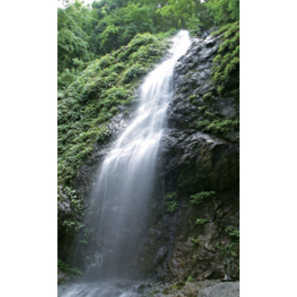
Nearby stands a shrine dedicated to Fudo Myo-o, the Buddhist deity of fire and wisdom.
Rocks Forming the Base of the Rootless Mountain
Aoiwa Park
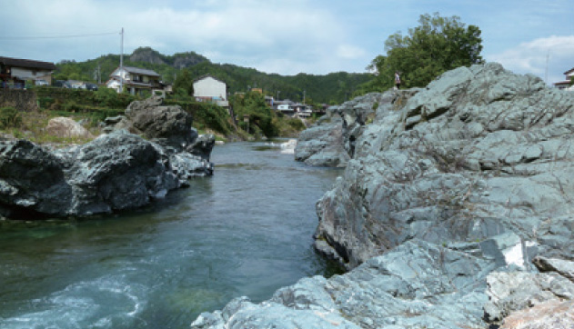
A park featuring green stone slabs formed from ancient submarine volcanic activity. Located at the confluence of the Kabura and Nanmoku rivers, the riverbanks reveal a colorful variety of stones.
HAKUENKA Plant – Shiraishi Industry
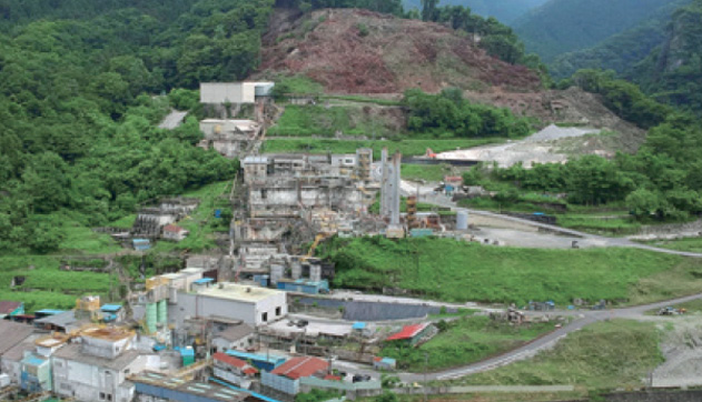
This factory produces calcium carbonate from limestone, which is the fossilized remains of ancient coral reefs.
Note: Limestone is no longer mined in Shimonita. Only the exterior of the factory can be viewed; the interior is not open to the public.
- Geo
- Aoiwa Park, the seven Rootless Mountains (including Mt. Ontake, Mt. Ōgui, Mt. Yotsumata, and Mt. Fuji, etc.), Slip Surface of the Atogura Klippe, Folding in Okuwabara, Reversed Layer in Miyamuro, Fudo Falls in Maita, Okukuriyama Gorge, Nakaosaka Iron Mine
- Culture
- Hakuenka Plant of Shiraishi Industry, konjac fields and traditional stone walls
- Bio
- Limestone-loving plants (such as Dryopteris kiusiana and Prunus bukouensis)
2. Ancient Volcanic Region Dividing the Pacific and the Sea of Japan
Mount Arafune is an ancient volcano located on the border between Gunma and Nagano prefectures. Rivers flow from the mountain—eastward to the Pacific Ocean and westward to the Sea of Japan.
Mount Myogi is also an old volcano, known for its dramatic rock formations like natural stone gates. It is designated as a National Place of Scenic Beauty and is considered one of Japan’s Three Great Rare Scenic Spots.
The Arafune Wind Cave is a World Cultural Heritage Site that uses landforms where cool air blows out even in summer. Nearby, Kozu Farm, Japan’s oldest Western-style ranch, sits on a wide, flat area formed by a landslide.
Mount Arafune
The mountain is a remnant of massive volcanic activity, where lava once erupted. It is one of Japan’s “200 Famous Mountains” and is a popular destination for hikers.
Mount Myogi
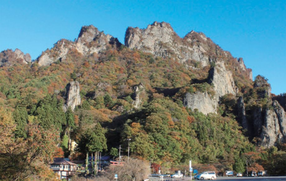
Together with Mount Akagi and Mount Haruna, Mount Myogi is part of the Jomo Sanzan (Three Famous Mountains of Gunma). Its dramatic natural rock formations—like the Stone Gates, Cannon Rock, and Candle Rock—leave a lasting impression on visitors.
Arafune Wind Cave (World Cultural Heritage Site)
Cold air still flows from the rocky slopes formed by collapsed solidified magma. From the Meiji period to early Showa, it served as one of Japan’s largest silkworm egg storage facilities, supporting the silk industry along with the Tomioka Silk Mill.
Jii and Baa
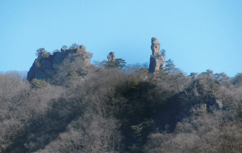
The rocky peak on the far right is called “Baa” (Grandma), the next is “Jii” (Grandpa), and the cluster on the left is known as “Kotatsu” (Heated Table). These whimsical rock formations were sculpted by wind and rain over many years from volcanic deposits.
Kozu Farm
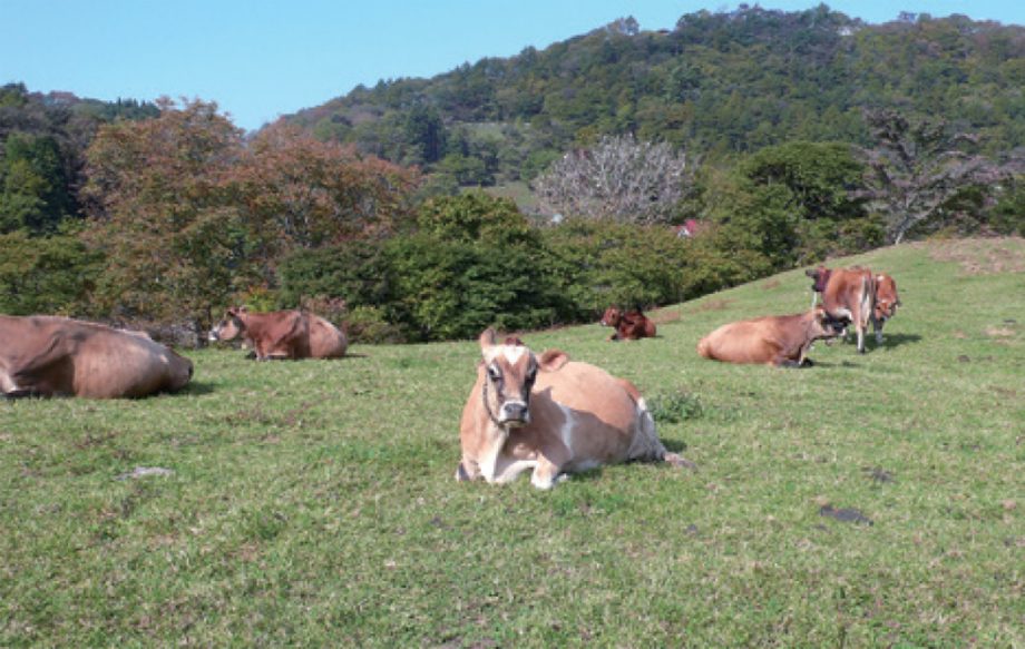
Japan’s oldest Western-style farm. It produces and sells high-quality dairy products made from fresh Jersey milk. The daily “cattle parade” across the pastures is a must-see.
Keikanseki (Cock’s Comb Stone)
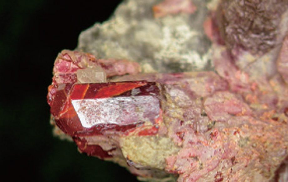
Gunma Prefecture’s official mineral (from the Nishinomaki Mine site)
This rare arsenic-bearing mineral was formed due to volcanic activity.
Note: This is private property and collecting is not allowed. The mineral is toxic—handle with care.
Mount Arafune Summit
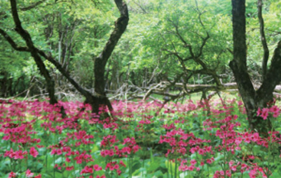
The summit is flat for about 1.2 km. The area is home to a mizunara (oak) forest and a wetland where primula japonica (kurinsō) and ligularia stenocephala (otakarakō) grow naturally.
- Geo
- Mount Arafune, Jii and Baa, Mount Myogi & Stone Gates, Keikanseki
- Culture
- Kozu Farm, Arafune Wind Cave, hot Springs, former Mining Sites
- Bio
- Chazubomi moss, plants named after Mount Myogi (e.g., Myogi fern, Myogi bellflower)
3. A Crossroads of Eastern and Western Culture and Trade
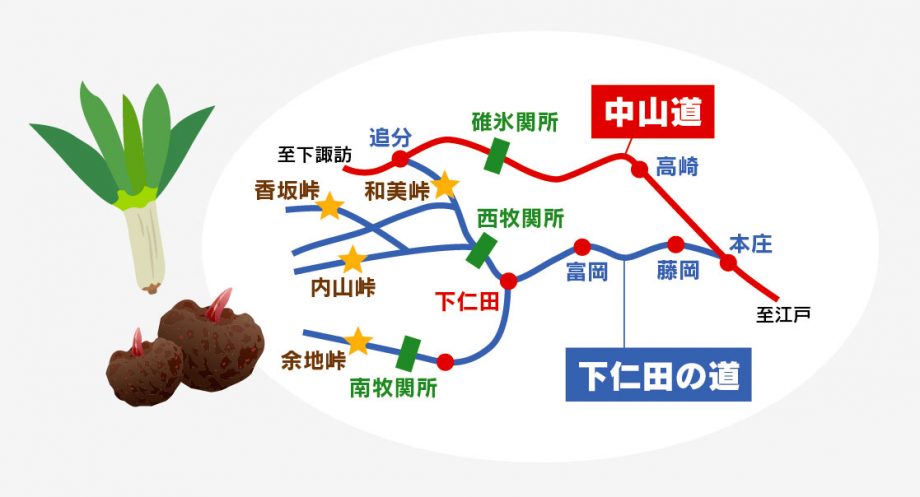
Shimonita Town lies in a valley carved by the east-west flowing Kabura River. The “Shimonita Road,” which connected Bushū and Jōshū with Shinshū (present-day Nagano), served as a trade route even in the Stone Age, when obsidian from Shinshū passed through here. From the early modern period, rice from Shinshū, whetstones from Nanmoku, and local specialties such as hemp, silk, paper, and limestone from Shimonita were also transported along this route. Today, Shimonita’s famous leeks and konjac continue to be loved by travelers.
Median Tectonic Line
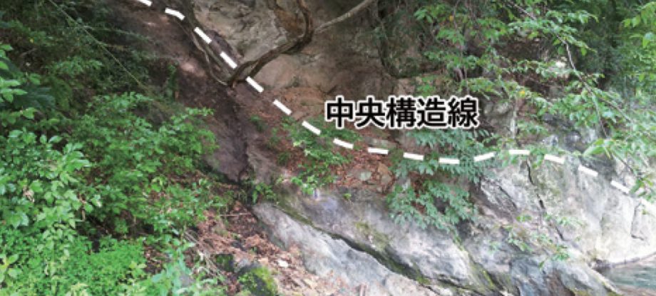
The only visible section of the Median Tectonic Line in the Kanto region
The riverbed across from Suwa Shrine in the town center reveals the Median Tectonic Line, a massive fault line running east to west across the Japanese archipelago. The east-west orientation of the Kabura River valley is a result of this geological feature.
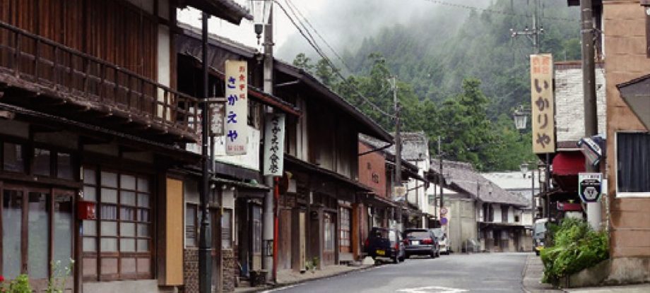
Motojuku (Former Post Town)
Mayama Hills
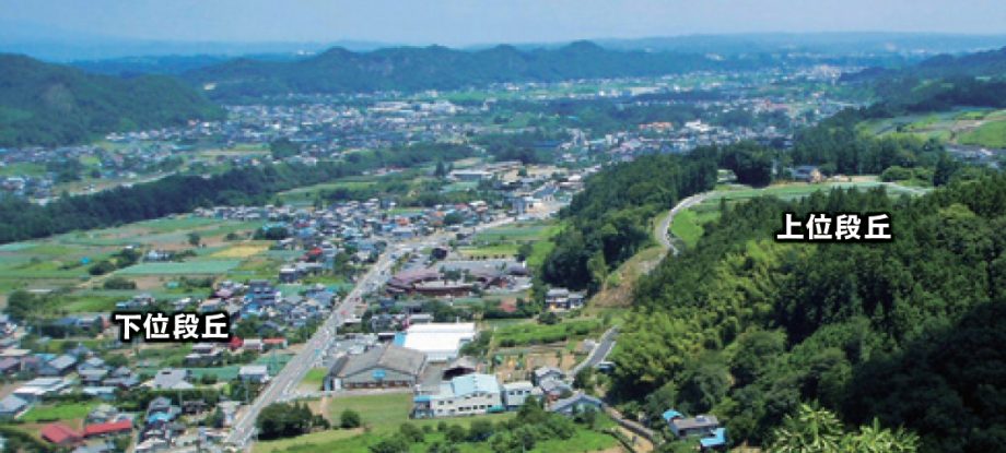
The Mayama area features two levels of river terraces. The upper terrace has many prehistoric archaeological sites, and a mountain castle once stood here in the Sengoku period. Today, it is a major production area for the specialty Shimonita Negi.
Shimonita Hydrangea Park
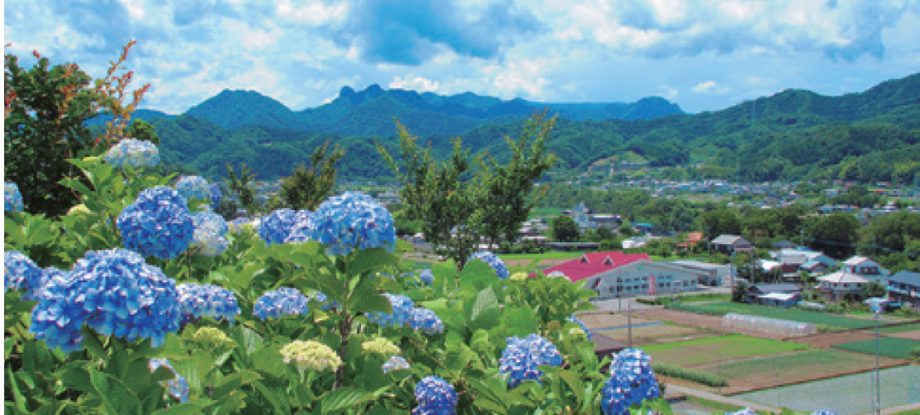
This garden takes advantage of the escarpment of the Mayama terraces. From mid-June to early July, the Hydrangea Festival is held here, and visitors can enjoy panoramic views of the mountains of Western Jōshū from the garden.
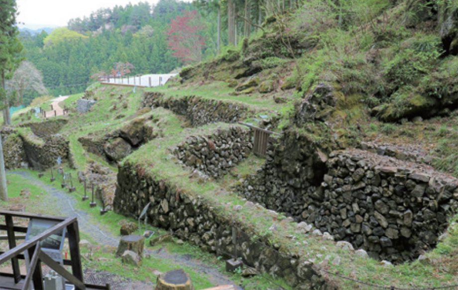
Konjac Processing Factories
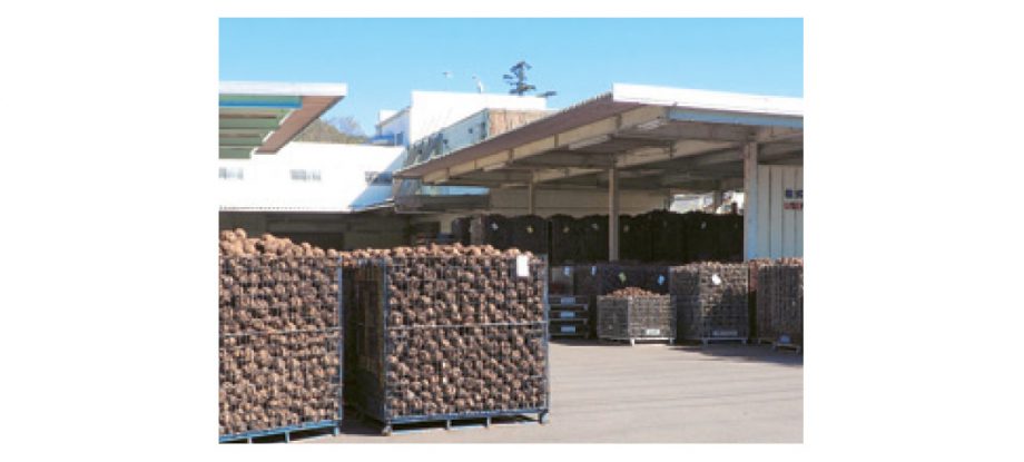
Shimonita’s valley terrain was ideal for waterwheel-powered konjac flour production. Even today, although electric power is now used, Shimonita remains one of Japan’s leading konjac processing regions, with konjac tubers arriving from all over the country.
Sukiyaki

Sukiyaki made with Shimonita-negi (Shimonita leeks), konjac, and shiitake mushrooms is a beloved dish in school lunches and local households.
Jōshin Dentetsu Shimonita Station
Selected as one of the Top 100 Stations in the Kanto Region
The Jōshin Railway line opened in 1897 between Takasaki and Shimonita to transport the area’s abundant resources. Around the station, you’ll find nostalgic retro streetscapes from the Showa era.
Suwa Shrine
Suwa Shrine features a magnificent main hall adorned with elaborate wood carvings on its pillars and beams. Its autumn festival has been held since the Tenpō era (1830–1844), and is celebrated with grand processions of mikoshi (portable shrines) and festival floats.
Shimonita War Historical Sites
In the final years of the Edo period, a battle took place here between the Mito Tengu Party and the Takasaki Domain. Historical remnants of both camps and their burial sites can still be found throughout the town.
- Geo
- Mayama Hills and the Archaeological Route (upper terrace), flatlands between Shimonita and Mayama (lower terrace), Tōrazu Valley, Hanekoshi Gorge, the Shimonita Formation, Kawai Fault (Median Tectonic Line)
- Culture
- Townscape of Shimonita, Shimonita Station, Suwa Shrine, Shimonita War Sites, Konjac Flour Industry, Grave of Dōsai Takahashi, Kosakasaka Pass Road, Onigasawa Bridge, Honjuku post town ruins, Beizan-ji Temple (site of Mayama Higashijō Castle), Hydrangea Garden (terrace cliff utilization)
- Bio
- Shimonita Negi fields, Abuta Fukujusō Flower Park